I thoroughly enjoyed our tour of Balcony House at Mesa Verde NP and even though we have been climbing ladders and crawling through tunnels AND it is late afternoon and quite warm when we are finished–knowing we are leaving the area next day–I want to fit in a hike afterward. The Petroglyph Point Trail piques my interest so we make our way to the trailhead. It is about 3:45 and the park ranger cautions us the gate at the entrance to the trail is locked promptly at 5 PM so we should pay close attention to the time and our progress if there is any chance we might not want to hike the full 2+ mile loop. (I have found some discrepancy as to the actual length of the hike. Sources cite anywhere from 2.4 to 2.9 miles.) Not do the full hike…do we look like amateurs?! So we sign the trail register giving our names, type of vehicle, state of licensing and the time. I find it interesting there is no requirement to log back in when finished. In fact, the register is inside the gate making it impossible to do so–even if required–if one returns after 5:00. At what point does someone think we may be lost or injured and come looking for us? Do they not realize how much I like to climb out on overhanging rock ledges? 🙂
The trail is paved heading down into the canyon for a short distance before stone steps take us to the dirt trail as it splits off and starts the ascent up the other side. It’s mostly shady and cool at first but eventually even the intermittent shade isn’t enough and we are *very* grateful we have our water bottles with us. The vegetation is lovely; a mix of evergreen and deciduous trees, flowering groundcover, wildflowers, yucca and cacti line the trail and decorate the landscape along with massive rock outcroppings scattered throughout. Sometimes it seems the trees and plants grow right out of the rocks.


It isn’t long before the trail gets even more interesting. This hike is rated as moderate but I didn’t see anything in the brochure that mentioned tight spaces. As we enter the narrow passageway (I’m guessing only about 30″ wide, at the narrowest point) I am acutely aware that not everyone would want–nor be able–to continue through to the other side. But with the rock face on the left and the mountainside dropping down and away on the right, there is no way to get past this point except straight through. Fun! And shady!
 Continuing on, we encounter steep staircases and low-hanging rock ceilings, all the while gaining in altitude *and* temperature…now mostly in full sun. I notice a small cave and take the opportunity to get some shade for a couple of minutes.


After a brief respite we continue on. The trail winds past a parade of tall pines. The view of the surrounding mesas and the canyons below is amazing.


We have been on the trail for almost an hour and I am beginning to wonder if we’re actually going to see the petroglyphs. Surely they will be obvious…or have a marker at least? Maybe we should have paid the 50 cents for the trail guide? I begin looking more carefully on the rocks as we pass by.


Finally! The petroglyph area is much smaller than I expect and some parts are in the shade but it is still well worth the experience. According to one Hopi elder, this petroglyph may tell the story of two clans (the Mountain Sheep Clan and the Eagle Clan) separating from other people and returning to their place of origin. 


 After spending some time appreciating the ancient etchings it’s time to get moving again. Just a short distance beyond, the trail begins to climb again. And it isn’t too much farther until we come to a large boulder formation that we must climb up and over using just hand and foot-holds. (Sadly, I guess I was too busy climbing and only took a picture of the bottom part of the formation.)
 The last half of the hike takes us up on top of the mesa and is relatively flat, for which my knees are thankful. (Unfortunately, we haven’t been hiking enough lately to really keep in shape and my body likes to remind me I’m not 18 anymore.)


I am enjoying the scenery–both flora and…um…”fauna”–when I see it. There is the rock I want to climb out on! Much to my delight it is easily accessible and Jim offers to take a picture or two. It’s quite windy up here on the exposed rock flat so I agree to be extra cautious and sit for the photo op. At first, I sit well away from the edge but then just couldn’t help but get out on the point. 

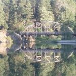
 I drag myself off the rock and we finish the hike (well after 5:00, btw). As Jim mentioned in his previous post, the Spruce Tree House access is closed–normally, these ruins are part of the Petroglyph hike–so our last view of cliff dwellings is from the end our trail.
 Mesa Verde NP is such a great place to visit and we definitely plan to return. Have you done any of the hikes in the park? We’d love to here about your experience(s)!


Great pictures!!! The Petroglyphs are really cool but you would have lost me before that, the little narrow space to go through doesn’t appeal to me, I am not comfortable in tight spaces even though I could easily fit. Thanks for posting the pic’s, I left N.H. Sunday afternoon and am currently in Grants N.M. and leaving this morning for Vernon Ariz where my Parents live, its been quite a drive for my dog Bubba and I but it feels good to almost be there. Looking forward to check out this part of the country and I definitely plan on going to the RTR in January, but plenty to do before that! Have a great summer, Steve
Thanks so much, Steve! Glad you enjoyed the pics!
Wow, all the way from NH is quite a drive! Hope you and Bubba enjoy your time visiting your parents and seeing some of the amazing places in the southwest.
Maybe we’ll see you at the RTR. Safe travels!
Jim & Annie